Show the map
Les Arcelles - Fort de Montavie - Echirolles
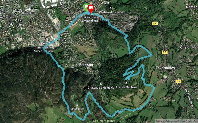


12 km
430 m
430 m
 Eybens (38)
 Eybens (38)
 Points of Interest table
| Accum. | Intermediary | |||||||
|---|---|---|---|---|---|---|---|---|
| POI | Description | Alt. | Dist. | D+ | D- | Dist. | D+ | D- |
Trace n°110468
Ascent threshold : 3 m Distance threshold : 0 m Smoothing : No Origin of altitudes : TrailConnect Android (baro) - GPS
Ascent threshold : 3 m Distance threshold : 0 m Smoothing : No Origin of altitudes : TrailConnect Android (baro) - GPS
Loop
Dominant terrain : Path
Max alti. : 591 m
Avg alti. : 410 m
Min alti. : 272 m
Longest ascent : 320 m
Longest descent : 190 m
Route completed by the author : Yes
Dominant terrain : Path
Max alti. : 591 m
Avg alti. : 410 m
Min alti. : 272 m
Longest ascent : 320 m
Longest descent : 190 m
Route completed by the author : Yes
Elevation profile
More tools
Create a new roadbook page
Map and track on your website
Warning ! When you insert a Trace de Trail map on your website, you agree not to hide any element of the module (links to Trail Trail or Trail Connect banner)
Add a realisation
Validate
Add a realisation to share your chrono and describe the conditions that you encountered during you trail running !
Add a comment
Validate
mathart
26/03/23, 19:55:28
fait aujourd'hui ! agréable sauf la partie goudronné pour récupérer le golf. les descentes il y a beaucoup de gros cailloux dommage on peut pas trop envoyer.
26/03/23, 19:55:28
fait aujourd'hui ! agréable sauf la partie goudronné pour récupérer le golf. les descentes il y a beaucoup de gros cailloux dommage on peut pas trop envoyer.
Show the infos
Add a track